 Suroît
Routing
One route per model, computed with the polar of each of your sails, then refined to win back the last few minutes.
Built to last a transatlantic
An offshore route plays out over days of forecasts that change with every run. Suroît computes fast over whatever duration you want and tells you what the route is worth when the models disagree.
Seventeen models, from the bay to the ocean
Near the coast, the 2 km high-resolution models: AROME, ICON-D2, UKMO and HARMONIE. Over Europe, ICON-EU, ARPEGE and GEM. Offshore, the global models ECMWF, GFS, ICON, ARPEGE, UKMO, GEM and JMA, plus AIFS, the ECMWF artificial-intelligence model. The route is computed on each with the same start and the same polar: the fastest stands out at once.
Routes lasting several weeks
The time step grows with the forecast range, 20 minutes at the start and up to 3 hours. When a GRIB ends, Suroît moves on to the next one you have saved, from the finest to the coarsest. Saint-Malo → Pointe-à-Pitre over 14 days of GFS is computed in about twenty seconds in the browser, check included.
A second pass to win the minutes
After the first route, a finer calculation goes over a corridor around it, with headings every 2°. The fastest is kept. The isochrones shown are those of this route: every tack and every gybe falls on them.
Offshore, without a connection
Saildocs requests are prepared from the route, with the file size and the transfer time over Iridium. Competitors' positions are imported from the race files and ranked with your routes.
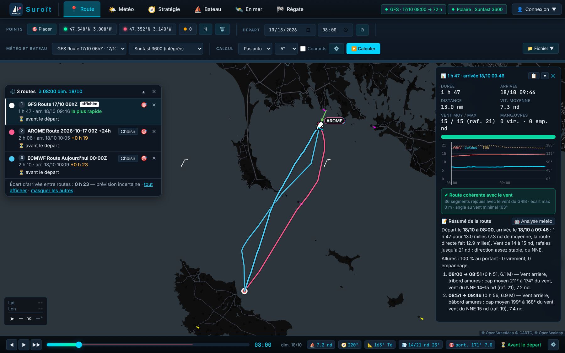
Same start, same polar, three models: 23 minutes apart at the finish between GFS, AROME and ECMWF for the 18 October outing. The ECMWF (51 members) and GFS (31) ensembles then give the spread of the forecast.
- Waves, currents and tides in the calculation
- Wind, gust and sea limits not to be exceeded
- Polars per sail: tick the sails on board, the calculation picks the fastest
- Best departure time and latest departure
Close to the rocks, when it pays
At the start of a race, the route is often won along the coast. The calculation spreads like an oil slick: it follows the SHOM coastline, rounds the headlands and goes into the bays.
It takes into account the draught, the under-keel clearance and the height of tide at the time of passage. It also flags isolated rocks and wrecks within 280 m of the route. Exclusion zones from the sailing instructions are drawn on the map or imported as KML, GPX or GeoJSON.